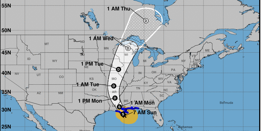
A tropical storm warning remains in effect for extreme southwest Alabama as Cristobal is expected to make landfall Sunday evening.
The National Hurrican Center warns conditions will deteriorate throughout the day as coastal flooding, dangerous surf and a high risk of rip currents are expected.
The environment has become favorable for brief tornadoes near the immediate coast. The tornado threat will gradually spread inland across southwest Alabama & southeast Mississippi Sunday afternoon and evening.
Maximum sustained winds in Cristobal remain at 50 mph, as of Sunday morning. Cristobal continues to track northward with a forward speed of around 12 mph, as it moves closer to the Louisiana coastline.
No significant strengthening is forecast prior to the landfall of Cristobal’s circulation center later today.
Rainbands from #Cristobal are beginning to bring Tropical Storm conditions to portions of the northern U.S. gulf coast. Flooding from heavy rain and storm surge along the coast are the biggest hazards. https://t.co/tW4KeFW0gB https://t.co/SiZo8ohZMN pic.twitter.com/aiWYbphhLO
— National Hurricane Center (@NHC_Atlantic) June 7, 2020
Dangerous surf conditions and rip currents have been observed on Dauphin Island.
⚠️Dangerous surf conditions and rip currents have been observed. ? For your safety, STAY OUT OF THE GULF WATERS TODAY! ? #mobwx https://t.co/gKwQxIH0cC
— NWS Mobile (@NWSMobile) June 7, 2020
The National Weather Service in Mobile issued several warnings regarding the extreme rainfall that is expected:
“Here are the key messages: Dangerous surf with 9-12 foot breakers and a HIGH rip current risk will persist well after landfall, through at least midweek. Coastal flooding with around 3 feet of inundation in northern Mobile Bay, 2-3 feet across coastal Alabama, and 1-3 feet across northwest Florida is likely Sunday and Monday during high tide (morning and afternoon). Heavy rainfall of 4-8″ with higher amounts up to 10″ possible, mainly across southeast Mississippi and coastal Alabama. Tropical storm force winds will begin this morning along the coast. The greatest chance of sustained tropical storm force winds is in coastal Alabama, with tropical storm force gusts mostly likely over northwest Florida and southeast Mississippi. Lastly, a few tornadoes are possible within rain bands through tonight. Continue to monitor the latest forecasts.”


